
Highway maintenance transparency reports
Local highways maintenance - transparency core report 2026/27
How we maintain local roads, pavements, and the wider highway network in Telford and Wrekin
What we are responsible for maintaining
The authority manages a diverse highway network that supports residents, businesses, and visitors, including:
Carriageways: 1,084km
Footways: 1,107km
Bridges and structures: 250 highway bridges, culverts and subways, together with approximately 200 retaining walls
Highway drainage assets: 36,000 gullies
Street lighting assets: 25,219 lighting points, 532 illuminated bollards and 1,387 lit signs
Traffic signals: 54 junctions and 71 signalised crossings.
Much of the area was developed as a New Town in the 1960s and 1970s, with modern highway assets built to a high standard. In contrast, some older routes rely on historic assets.
This network presents several challenges. As the newer infrastructure ages, many assets are now deteriorating and nearing the end of their operational lives. While proactive and preventative investment in carriageway assets has been strong, investment has historically focused on carriageways, while the ageing profile of other highway assets is creating increasing future maintenance requirements. High traffic volumes, including freight and public transport, accelerate wear and deterioration, particularly on key routes. Weather impacts such as heavy rainfall, freezing conditions, and extreme temperatures can further damage surfaces and drainage systems. Balancing budget constraints and minimising disruption to road users remains a key operational challenge.
Road conditions in Telford and Wrekin
Details of road condition within Telford and Wrekin are provided below, together with further context to support interpretation of the data.
A roads
Year | Percentage of road in red category | Percentage of road in amber category | Percentage of road in green category |
|---|---|---|---|
2023 | 7% | 29% | 63% |
2024 | 7% | 32% | 61% |
2025 | 6% | 36% | 58% |
B and C roads
Year | Percentage of road in red category | Percentage of road in amber category | Percentage of road in green category |
|---|---|---|---|
2023 | 5% | 26% | 69% |
2024 | 5% | 31% | 64% |
2025 | 6% | 37% | 57% |
U roads
Year | Percentage of road in red category |
|---|---|
2023 | 6% |
2024 | 6% |
2025 | 5% |
Councils use road condition surveys to assess the state of their roads. The results are grouped into three categories:
Green – the road is in good condition and no further investigation or treatment is required
Amber – the road may need maintenance soon
Red – the road is in poor condition and should be considered for maintenance.
The published official statistics for road condition include more detail about the methodology, timing and coverage of this data.
Additional information on carriageway condition
The condition figures reflect the change from SCANNER surveys to Actual Engineer Inspections (AEI). AEI applies engineering judgement to identify road lengths requiring treatment, based on overall condition, treatment need and network performance. It reports the full length over which an intervention would be delivered, rather than the combined length of individual defects. The physical extent of isolated defects will therefore be much smaller than the reported treatment length.
The 2025 red percentages equate to indicative treatment lengths of approximately 6.6km of A roads, 19.8km of B and C roads and 26.3km of unclassified roads. These figures identify roads for consideration, not a confirmed programme. This approach reflects how maintenance is delivered in practice, applying appropriate treatments across coherent road lengths to provide effective, longer-term asset management outcomes.
What are we doing about potholes and other road defects
What is a pothole?
A pothole is defined in the Highways Inspection policy as “an area of material loss resulting in a vertical edge depression”. Investigatory levels are:
Carriageways and unmetalled cycleways - 20mm deep and 300mm wide in any horizontal direction
Footways and Cycleways – 10mm deep and 50mm in any horizontal direction.
Potholes form when water enters cracks in the road surface, weakens the underlying layers, and traffic loading breaks up the surface. Freeze-thaw cycles, ageing materials, poor drainage, and repeated heavy vehicle movements accelerate deterioration.
What we are doing to tackle potholes
Telford & Wrekin Council adopts a risk-based approach to highway safety inspection and maintenance to manage potholes and other carriageway defects. Roads are inspected periodically with defects identified for repair from inspections and customer reports. A number of reactive maintenance techniques are used to repair potholes including:
Permanent Patching
Cut out hot asphalt inlay
Mastic patching
Temporary Patching
Cold lay patching
Spray injection patching
During financial year 2025/26, the authority filled 3,252 potholes across the network.
A key element of the authority’s approach is preventative maintenance, including surface dressing, microsurfacing, joint sealing, retexturing and other asset management treatments designed to extend pavement life and prevent potholes from forming. This supports long-term network resilience and helps reduce the need for reactive repairs.
Where it is safe, practical and cost-effective to do so, the authority prioritises permanent repairs to minimise repeat visits and reduce disruption to road users. However, operational, safety and programme-management considerations may mean that a temporary repair is required initially. Examples include severe weather, emergency situations, traffic management constraints, utility works, limited road space, or the need to undertake more extensive structural repairs as part of a planned scheme.
On occasions, temporary repairs are used to make locations safe while a permanent solution is planned. This approach ensures risks are managed appropriately, resources are targeted effectively, and repairs are delivered in a way that provides best value while maintaining network safety and serviceability.
How members of public can report potholes and other highway defects
Members of the public can report potholes and other highway defects directly to Telford & Wrekin Council using the Council’s online reporting system. Reports are submitted through the Council’s digital self-service platform, which allows issues to be logged online and directed to the appropriate service team.
The Council also offers MyTelford, an online account service that enables residents to submit reports, view their reporting history and track the progress of requests. This provides a more efficient process for communicating with the Council and monitoring defect reports.
Report a problem with a road, path or verge
What happens after a pothole is reported
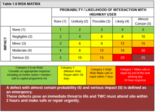
After a pothole or highway defect is reported, Telford & Wrekin Council records the report and arranges an inspection. The defect is assessed using the Council’s highway inspection policy to determine the level of risk it presents to road users and inform the response.
Defects are assessed according to their size, location, road hierarchy, traffic volumes and the risk they present to highway users. High and Medium risk defects are repaired within defined response times, while low risk defects are considered for the most appropriate response.
Highways inspectors assess the risk using the following risk matrix:
What we spend to maintain the highway network and where the funding is coming from
Spending on highways maintenance
| 2024-25 | 2025-26 | 2026-27 (projected) |
|---|---|---|---|
Total spend on highways maintenance | £11,936,993 | £17,465,635 | 19,983,987 |
Of which spent on: | |||
Carriageways | £5,854,273 | £7,997,220 | £8,109,490 |
Footways | £1,286,437 | £2,167,406 | £1,883,790 |
Structures (for example bridges or tunnels) | £892,257 | £1,808,124 | £1,601,520 |
Drainage | £902,288 | £1,017,006 | £882,590 |
Street lighting | £1,355,161 | £1,550,117 | £2,022,399 |
Other assets | £1,646,577 | £2,925,762 | £5,484,198 |
Where our funding for highways maintenance comes from
Funding Sources for highways maintenance | 2024-25 | 2025-26 | 2026-27 (projected) |
|---|---|---|---|
Funding received through the Department for Transport / UK Government | £5,805,000 | £12,859,843 | £15,203,850 |
Additional highways maintenance funding provided by the Council or third parties | £6,131,993 | £4,605,792 | £4,780,137 |
Total | £11,936,993 | £17,465,635 | £19,983,987 |
Our maintenance plans for this year
Our plans for highways maintenance for 2026/27
The published Highways & Transport Capital Investment Programme 2026 - 2030 (.pdf size: 384kb) includes more than 80 improvements during 2026/27:
Carriageway resurfacing: 8.58km of roads programmed for structural resurfacing to renew end-of-life carriageways and improve network condition.
Preventative carriageway treatments: 20.57km of roads programmed for surface dressing and asphalt preservation to extend pavement life and reduce future defects.
Footway renewal: 29.38km (52,000m²) of footways programmed for preventative maintenance to improve safety, accessibility and condition.
Structures: Repairs to Longdon upon Tern Bridge, reconstruction of Parkway East Retaining Wall, replacement decking at Jackfield Footbridge, concrete repairs at Aqueduct Old Bridge.
Street lighting: Replacement of 100 ageing columns and continued investment in LED lighting, now installed on 99.2% of the network.
Accessibility and road safety: Over 60 dropped kerbs, four safety schemes, four zebra crossings, two new signalised crossings, two upgraded crossings and one junction refurbishment with improved walking and cycling facilities.
Full list of planned carriageway and footway works
The full list of schemes planned for delivery is published on our planned works webpage.
How decisions are made on our maintenance plans
Highway maintenance is prioritised using a risk-based asset management approach that combines condition survey data, safety inspections, defect history, network hierarchy and lifecycle planning. Schemes are selected where intervention will provide the greatest whole-life value, reducing future deterioration and preventing more costly reconstruction.
The treatment choice is determined by the asset condition and failure mechanism rather than a one-size-fits-all approach. Options such as surface dressing, patching and resurfacing are assessed to ensure the most appropriate and cost-effective intervention is applied to each site.
Efficiency is achieved through:
Forward programme development
Coordination of works between different asset groups
Grouping works geographically and by treatment type.
This maximises contractor productivity, reduces mobilisation costs and minimises disruption. The Council also coordinates with utility companies and other planned highway activities to avoid abortive work and repeated network occupation.
Transparency report – Technical Annex
Last updated : 10 September 2026